Bagerhat Tourist Places are Khan Jahan Ali's Tomb Complex, Mongla Sea Port and much more.
Sundarbans is very near for here.
Bagerhat District Information
Bagerhat district is under Khulna Division of Bangladesh. It is in the South-western part of Bangladesh. Once it was under the Khalifabad Pargana. Bagerghat is also known as the city of Mosque, a large number of mosques in the district. Khan Jahan Ali's tomb is one of the main attractions for tourist of Bagerhat. The Shat means sixty Gambuj Mosque built in 1459. Bagerghat was declared as a district only in 1984. Sundarbans, Mongla port are in this district. There are many interesting
tourist places to visit.
List of Top Bagerhat Tourist Places
- Ajoddha Temple
- Bagerhat Government Boys School
- Buffalo Cultivation Centre
- Chandra Mahal, Ronjitpur
- Durgapur Shiva Math
- Ghora Dighi
- Hiron Poient
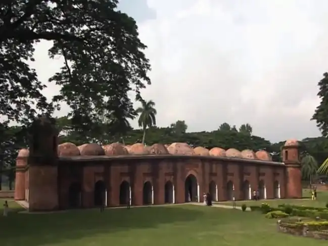
- Khan Jahan Ali's tomb Complex
- Khan Jahan Ali's Tank
- Kodla Math
- Modhumala Temple and Lake
- Mongla Sea Port
- Panighata Lake
- Robart Morel Monument
- Rampal Lake
- Rajbari of Banagram
- Saint Paul's Church
- Shat Gambuj Mosque
- Sona Mosque
- Sundarban
- Sundarban Museum
- Shundarban Resort, Barakpur
- Tagore Lake
Upazilas and Thanas
- Bagerhat Sadar Upazila,
- Chitalmari Upazila,
- Kachua Upazila,
- Fakirhat Upazila,
- Mollahat Upazila,
- Mongla Upazila,
- Morrelganj Upazila,
- Rampal Upazila,
- Sarankhola Upazila.
Border and bounded By
- Gopalganj and Narail district on the north
- The Bay of Bengal on the south
- Gopalganj, Pirojpur and Barguna district on the east
- Khulna districts on the west
Weather / Temperature
- Highest average temperature: 00 °c Celsius
- Lowest average temperature: 00 °c Celsius.
- The average amount of rainfall: 000 mm.
District Travel and Tourism Information for Travelers
| Area |
3,959.11 Square Kilometers |
| Main River |
Panguchi River, Daratana River, Madhumati River, Pasur River, Haringhata River, Mongla River, Baleswar River, Bangra River and Goshairkhali River. |
| Geo Position / Location |
22°40′N 89°48′E |
| Division |
Khulna Division |
| Country |
Bangladesh |
| Nearest Airport |
Jessore |
| Postal Code |
9000 |
| NWD Code |
0468 |
| ISD Code |
0088 |
| Currency |
Taka (BDT) |
| BD Govt. Website |
www.bagerhat.gov.bd |
Related Web Links