Satkhira Tourist Places
A list of top famous tourist spots, places, and attractions is given for visitors in Satkhira.
- Annapunna Nabaratna Mandir
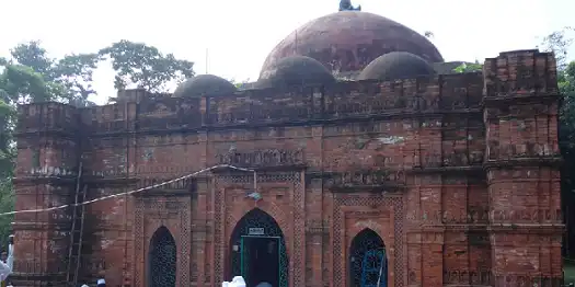
- Baro Duary (Ishwaripur, 1582)
- Bura Kha Lake
- Bala Pota Shiv Mandir at Kaliganj
- Chaygharia Jora Shib Mondir,
- Dargah of Mai Champa (Labasa, 1417)
- Dighi (pond) and clay-walled Moneyghar of Tittar Raja (Nawapara, 1582)
- Dokkhin Talpotti
- Gopalpur Mandir (terracotta decorated)
- GunakarKati Mazar of Hazrat Maulana Shah Abdul Aziz Khulnavi, GunakarKati (opposite of Budh Hata), Assasuni
- Hamman Khana (Ishwaripur)
- Jahajghata Naval Fort (Mautala, 1567)
- Joseshwari Kali Mandir (Ishwaripur, 1899)
- Karimondir
- Katunia Mandir
- Khan Bahadur Ahsan Ullah Pak Raoza Sharif, Nolta, Kaliganj
- Mandarbaria Sea Beach
- Mojaffar Garden and Resort
- Moutala Mosque
- Mozaffar Garden
- Nagar Fort of Raja Pratapaditya (Kaliganj)
- Nabaratna Mandir (Demrail, 1580)
- Nagarghata Mosque
- Parabajpur Mosque (Mukundapur)
- Raja Prattyapadditta Hammamkhana
- Sapnabari
- Shai Jame Mosque at Kaligang
- Sriula Boro Masjid, Sriula, Assasuni
- Shrine of Nalta
- Shrine of Gunakarkati
- Shamsundar Temple
- Sonabaria Nabaratna Mandir (Kalaroa, 1767)
- Sundarban (mangrove forest)
- Sultanpur Mosque
- Sonabaria Moth and Temple
- Tenga Mosque (Banshipur,1599)
- Tetulia Jame Mosque
- Triangular Mandir of Chanda Bhairabi (Ishwaripur)
About Satkhira
Satkhira is a district under Khulna Division. It is in the southwestern part of Bangladesh. It lies along the border with West Bengal, India. The district consists of two municipalities, seven Upazilas, 79 Union Porishods, eight thanas (PS), and 1436 villages. It was known anciently as Burana Island. The subdivision was turned into a district in 1984. The name Satkhira has come from Sataghariya. This is mostly planned land.
Upazilas and Thanas
- Satkhira Sadar
- Assasuni
- Debhata
- Tala
- Kalaroa
- Kaliganj
- Shyamnagar
Tourism Information
| Area |
3,817.29 Square Kilometers |
| Main River |
Kopotakhi,, Morichap, Kholpotua, Betna, Raimangal, Hariabhanga, Ichamti, Betrabati and Kalindi-Jamuna River. |
| Geo Position / Location |
22.35 N 89.08 E |
| Country |
Bangladesh |
| ISD Code |
0088 |
| Currency |
Taka (BDT) |
Border and bounded By
- Jessore district on the north
- The Bay of Bengal in the south
- Khulna district on the east
- 24 Parganas district of West Bengal on the west
Related Links